June 2010

Créez une carte papier avec des données OpenStreetMap | GeoTribu
May 2010
Gapminder Desktop (beta)
(via)January 2010

Nokia offering free turn-by-turn navigation on smartphones globally (updated) -- Engadget
(via)"In other words, by making the platform more tempting through a robust feature set, Nokia will sell more high-margin smartphones and thus boost the bottom line."
D'un point de vue personnel et en tant qu'utilisateur, j'ai l'impression qu'il était temps que Nokia fasse un geste dans ce sens.

Gapminder.org
by 22 others
Ride with GPS
(via)"... a recreational route sharing community for cyclists, motorcyclists, runners, hikers, mountain bikers, and anyone else who is involved in a route-oriented sport."
Un des nombreux outils en ligne permettant de tracer un parcours d'après une carte Google Maps. Petit + : l'élévation des tracés à l'air assez précise.
November 2009
Geomap ou comment mettre en oeuvre rapidement sur le web des cartes choroplètes ou en symboles (presque) proportionnels
(via)
Cartographer.js
by 3 others (via)September 2009
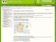
Cartographie interactive Géoïdd France
(via)
Calcul d'itinéraire (jogging, footing, course à pied, vélo...)
by 1 other"... permet de calculer la distance totale, ainsi que le dénivelé, d'un parcours sportif effectué (jogging, footing, course à pied, vélo, roller...) en plaçant des points sur la carte."
July 2009
OpenStreetMap StaticMap - Create a map
(via)
June 2009
Web Maps Lite
(via)"CloudMade's Web Maps Lite API lets you embed our maps in your website." See also : Simple Map.
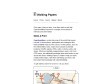
Walking Papers
by 1 other (via)May 2009
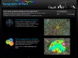
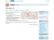
Topographie de Paris - Cartes du relief parisien - Relevés d'altitude dans Paris - Altimétrie de Paris
by 1 other (via)March 2009

Google Street View Time Lapse on Flickr
(via)
Bookmarklet pour passer de Google Maps à OpenStreetMap directement
by 1 other
QR code maker
(via)"... quickly create your own information pages for the mobile users."
A priori pratique aussi : QR Map.
February 2009


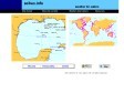
The Euro Invasion of France (2002)
by 2 othersJanuary 2009
Paris - Google Maps - Transit
(via)Nouvelle visualisation des transits métro et rer dans google maps.
A voir aussi ratp.fr.

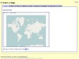
File:Communes of France.png - Wikipedia, the free encyclopedia
(via)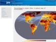
Travel time to major cities: A global map of Accessibility - European Commission
(via)December 2008
mapof.it
by 3 others (via)
Tiny Geo-coder
by 6 others (via)