January 2007
OpenStreetMap
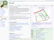
by 2 others« OpenStreetMap is a project aimed squarely at creating and providing free geographic data such as street maps to anyone who wants them. »
December 2006

November 2006
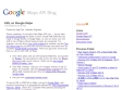
KML on Google Maps
(via)« To view a KML or KMZ file on Maps, just go to Google Maps, and instead of searching for a geographical address like 1600 Amphitheatre Parkway, 94043, search for a complete Web address (including the "http://" part) of your KMZ file, like http://kml.lover.googlepages.com/cropcircles.kmz. »
Life of a Geolocated Blog Post
by 1 other (via)« View entire photo sets as self-contained KMZ files in Google Maps »
MapLib.net
by 1 other (via)« ... turn any image you uploaded as large as 6000*6000 into a custom Google Map in a really simple way. You can maintain markers for it, as well as embed it in your own web pages or blog. »