2009
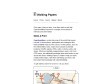
Walking Papers
by 1 other (via)"Print maps, draw on them, scan them back in and help OpenStreetMap improve its coverage of local points of interests and street detail." Excellent et prometteur...
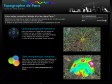
Topographie de Paris - Cartes du relief parisien - Relevés d'altitude dans Paris - Altimétrie de Paris
by 1 other (via)En effet, pratique pour visualiser l'altitude d'un lieu dans Paris.
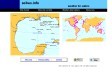
Paris - Google Maps - Transit
(via)Nouvelle visualisation des transits métro et rer dans google maps.
A voir aussi ratp.fr.
2008
Sailwx.info: Weather for Mariners
(via)Météo et plein d'autres ressources pour les marins. A voir en particulier le suivi d'un grand nombre de navires sur toutes les mers du Monde.

geohash.org is public!
(via)« geohash.org offers short URLs which encode a latitude/longitude pair, so that referencing them in emails, forums, and websites is more convenient. »
2007
Return Latitude and Longitude Fast with Google Maps
by 1 other« Whenever you require a location coordinates on a google map click the bookmark and a prompt box displays the in latitude and longitude. »
2006
MapLib.net
by 1 other (via)« ... turn any image you uploaded as large as 6000*6000 into a custom Google Map in a really simple way. You can maintain markers for it, as well as embed it in your own web pages or blog. »
1
(8 marks)