2013
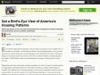
See the big picture of how suburban developments are changing the country's landscape, with aerial photos and an architect's commentary
Even before Google allowed anybody with an Internet connection to see a satellite view of anyplace on the globe, I loved looking at books with aerial photography. A few favorites that focus on natural and human-made landscapes of the United States are Alex S. MacLean's Designs on the Land: Exploring American from the Air, Dolores Hayden's and photographer Jim Wark's A Field Guide to Sprawl and Alan Berger's Drosscape: Wasting Land in Urban America.

Breadpig Shop - Buy Geeky Things & Make the World Suck Less! — Balloon Mapping Kit
Once assembled, this kit -- developed by community researchers from the Public Laboratory for Open Technology and Science -- enables you to collect your own aerial photos from up to 1000 ft. Using the open source MapKnitter web-based software, you can stitch the resulting images into a web-viewable map -- your own "counter-cartography" Google Maps. Use it to tell a different story from the "official" map -- document contamination (it was used to map the BP oil spill) or wetlands loss, or to record a temporary condition like the Occupy Oakland encampment.
2011
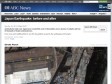
ABC News - Japan Earthquake: before and after
by 3 othersAerial photos taken over Japan have revealed the scale of devastation across dozens of suburbs and tens of thousands of homes and businesses.
Hover over each satellite photo to view the devastation caused by the earthquake and tsunami.
Development: Andrew Kesper
Source: Google
2009

1
(4 marks)