2013

2011
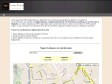
CodesScripts.fr | Latitude et longitude avec Google Maps
Cette page utilise l'API Google Maps pour déterminer des coordonnées géographiques (latitude et longitude).
Les coordonnées sont données en degrés décimaux, comptés positivement vers le Nord pour la latitude, et vers l'Est pour la longitude. Les valeurs calculées par l'API Google Maps ayant une précision illusoire, elles sont arrondies à 7 chiffres après la virgule, ce qui correspond à une précision de l'ordre du centimètre, largement suffisante pour les utilisations courantes!
Google Maps API Example: Simple Geocoding
Coordonnées GPS d'apres une adresse et plan Maps Goggle
2010
1er Twunch Metz « La Moselle sur le web
RT @Passyr: #TWM 1er #twunch #Metz infos ici http://bit.ly/11VjvP -- inscriptions ici http://bit.ly/7FGZS (19 participants) RT PLZ [from http://twitter.com/kemar/statuses/3540251934]

Ride with GPS
"... a recreational route sharing community for cyclists, motorcyclists, runners, hikers, mountain bikers, and anyone else who is involved in a route-oriented sport."
Un des nombreux outils en ligne permettant de tracer un parcours d'après une carte Google Maps. Petit + : l'élévation des tracés à l'air assez précise.
2009
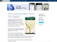
Official Google Mobile Blog: Announcing Google Maps Navigation for Android 2.0
Today we're excited to announce the next step for Google Maps for mobile: Google Maps Navigation (Beta) for Android 2.0 devices.

2008
Apple - Downloads - Math
A utility for uploading, downloading, and transcoding GPS data among GPS devices, GPX files, and KML files (for Google Earth). The resulting files can be used in a variety of applications available for the Macintosh, including TrackRunner, TrailRunner, and of course Google Earth.

Skyhook Wireless
Si vous trouvez qu'il est difficile de trouver où vous êtes avec la recherche automatique proposée par votre iPhone ou iPod Touch, vous pouvez maintenant référencer de nouveaux hotspots WiFi, à commencer par le(s) votre(s) !

Garmin s nuviphone brings the smartphone to GPS
The iPhone may have Google Maps, but it doesn t rely on real GP� it approximates your location using cell phone towers. And while there are smartphones with GPS out there, none contains a fully-featured GPS device.
2007

Google vulgarise le GPS !
"la nouveauté réside désormais dans un nouvelle fonctionnalité dans cet outil déja assez complet , qui en s’ appuyant sur la triangulation GSM des relais vous donne votre position dans les Plans de Google maps … un GPS pour mobile et gratuit (Hors coups Wap ! )"


Tous les McDonald’s de Belgique sur Google Earth et dans votre GPS !
Hors de ma vue mécréant ! Vinch a osé passé tout son samedi à encoder les données gps des 57 McDo de Belgique. Si c'est pas honteux ! Moi qui fait régime... bon, vais quand même télécharger tout ça, on ne sait jamais. :)
HoudahGeo - Geocoding for the Mac
HoudahGeo may operate in a fully automatic mode when provided a track log file from a GPS receiver. Finer control is possible by attaching photos to waypoints created using a GPS device.
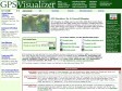
GPS Visualizer
GPS Visualizer is a free, easy-to-use online utility that creates maps and profiles from GPS data (tracks and waypoints), street addresses, or simple coordinates.
gpicsync - Google Code
GPicSync automatically inserts location in your photos metadata so they can also be used with any 'geocode aware' application like Picasa/Google Earth, Flickr, loc.alize.us, etc.
Geotagger
Geotagger is a droplet for inserting GPS coordinates into your photos.
Simply position Google Earth (version 4 only) over the location you wish to insert into your images, then drag your images (jpegs only) onto the Geotagger icon. Once the images are tagged the information stays with them so you can import them to iPhoto, upload them to Flickr or Panoramio or any number of other things. If you choose iPhoto you may want to check out a plugin I wrote that will export your photos to a KMZ file that you can open in Google Earth and see your photos on the globe.
MapMyRun.com -- Mapping your running routes has never been easier!
Find your Address in the "BEGIN HERE" box on the left, then click on the map below to plot your Walk. This site is great for your fitness, training, and wellness needs! You can Drag & Drop and Edit your points on your walk route. To Edit, click on the ico
GPS Visualizer: Google Maps input form
This form will automatically draw your GPS data (or KML/KMZ file, or plain text data in CSV or tab-delimited format) overlaid upon street maps and satellite imagery in Google Maps.


