October 2007

lejoe’s notes » Barcamp Lausanne | My talk titled “When location meets the web”
A good presentation giving a good overview on what can be done with GPS and web… the future of localization
slides from Lausanne BarCamp (liip rocks)
July 2007
June 2007

May 2007

April 2007
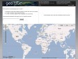
geotagged - Nicolas Hoizey's Tagged Photos - Google Maps
Mes dernières photos sur Google Maps en 10 secondes grâces aux flux GeoRSS de Flickr !
thebigpicture - Google Code
The Big Picture is an early attempt for a Python library to read and write Exif and IPTC metadata from and to JPEG and TIFF files. It is in a very early stage.
GPS Visualizer
GPS Visualizer is a free, easy-to-use online utility that creates maps and profiles from GPS data (tracks and waypoints), street addresses, or simple coordinates.
gpicsync - Google Code
GPicSync automatically inserts location in your photos metadata so they can also be used with any 'geocode aware' application like Picasa/Google Earth, Flickr, loc.alize.us, etc.
geotagged - Nicolas Hoizey's Tagged Photos - Google Maps
Mes dernières photos sur Google Maps en 10 secondes grâces aux flux GeoRSS de Flickr !
March 2007
scriptaMac.at - Software
The GeoTagging Automator Action automatically tags your images with geographical coordinates and elevation data from a GPS track file. It supports a great range of image formats, including many raw image formats like Canon CR2, Nikon NEF and Adobe DNG.

February 2007
About at The geoURI scheme
The ‘geo’ Uniform Resorce Identifier (URI) aims to facilitate, support and standardize part of the interaction with geospatial services and applications. Accessing information about or trigger further services based on a particular place on earth shouldn’t be any harder than writing an email by clicking on a ‘mailto:’ link.