2011

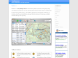
The Photographer's Ephemeris (TPE)
Sur un fond de carte provenant de Google Earth les azimuts de lever et de coucher de la Lune et du Soleil pour n’importe quelle date. En zoomant plus ou moins, vous avez ainsi une indication extrêmement précise de la position du disque lunaire (ou solaire) par rapport à la ligne d’horizon d’un lieu.
2008
cGPSmapper - Your Tool For Creating Maps
cGpsMapper makes it possible to create vector maps which can be uploaded to Garmin GPS receivers.
locr - locate your photos
With the free locr PC software, you are able to geotag photos automatically and simultaneously. All you need is a GPS-datalogger and the locr GPS Photo for Windows software.
GeoSetter for Windows
GeoSetter is a freeware tool for Windows for showing and changing geo data of image files (e.g. images taken by digital cameras).
2007
TrailRunner
TrailRunner is a route planning software for all kinds of long distance sports like running, biking, hiking, inline-skating, skiing and more. If you ever asked yourself how long your workout routes are and what route you should choose for this evening — then TrailRunner should be your training-partner.

Mindmapping Delicious = DeliciousMind - Vtech
Vtech, le blog de la veille technologique et de l'intelligence compétitive
2005
1
(7 marks)
