13 October 2007 12:00
Geographic Resources Analysis Support System
Commonly referred to as GRASS, this is a Geographic Information System (GIS) used for geospatial data management and analysis, image processing, graphics/maps production, spatial modeling, and visualization
13 October 2007 11:00
Hme - Height Map Editor
Hme is a 2D program, used for creating, manipulating and viewing height maps.

TerraVisionTM
TerraVisionTM is an Open Source distributed, interactive terrain visualization system developed by SRI International
13 October 2007 10:00
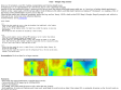
Virtual Terrain Project
The goal of VTP is to foster the creation of tools for easily constructing any part of the real world in interactive, 3D digital form.
1
(6 marks)