January 2014


superfreedraw / unlimited online drawing and the internet´s bathroom wall
No registration, no censorship. superfreedraw has been established to support the idea of a free and uncensored internet accessible by everyone all over the world. The established elite art system sucks. Everybody is an artist! This is the biggest collaborative artwork ever made.
December 2013

United States of Lego
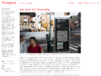
United States of Lego
50 States of Lego, photographed by Jeff Friesen. Map by Kenneth Field
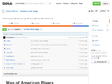
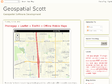
NelsonMinar/vector-river-map
This project contains everything you need from start to finish to make a vector based web map of American rivers in the contiguous 48 states. This demonstration map is neither particularly beautiful nor complex, but it is a complete example of how to build a web map using tiled vector data into a web map. The source code is open source you are encouraged to read and tinker with. There are three parts to the project: data preparation, HTTP serving of vector tiles, and clients that render maps. The components integrated in this project are:

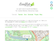
Leaflet - a JavaScript library for mobile-friendly maps
Leaflet is a modern open-source JavaScript library for mobile-friendly interactive maps. It is developed by Vladimir Agafonkin with a team of dedicated contributors. Weighing just about 33 KB of JS, it has all the features most developers ever need for online maps.

Proj4js by proj4js
JavaScript library to transform coordinates from one coordinate system to another, including datum transformations

November 2013


October 2013
September 2013


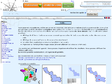
SilviaTerra Tech Blog: Offline Mapping in HTML5 Mobile Apps
One of our top feature requests for Plot Hound has been to add satellite/terrain layers to the cruise maps. We couldn't just drop in normal Google or Bing Maps because we needed the maps to be available out in the woods with no data connection.
August 2013
40 Maps That Will Help You Make Sense of the World
If you’re a visual learner like myself, then you know maps, charts and infographics can really help bring data and information to life. Maps can make a point resonate with readers and this collection aims to do just that.
Hopefully some of these maps will surprise you and you’ll learn something new. A few are important to know, some interpret and display data in a beautiful or creative way, and a few may even make you chuckle or shake your head.
If you enjoy this collection of maps, the Sifter highly recommends the r/MapPorn sub reddit. You should also check out ChartsBin.com. There were also fantastic posts on Business Insider and Bored Panda earlier this year that are worth checking out. Enjoy!
July 2013
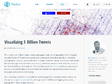
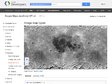
Visualizing 3 Billion Tweets | MapBox
This is a look at 3 billion tweets - every geotagged tweet since September 2011, mapped, showing facets of Twitter's ecosystem and userbase in incredible new detail, revealing demographic, cultural, and social patterns down to city level detail, across the entire world. We were brought in by the data team at Gnip, who have awesome APIs and raw access to the Twitter firehose, and together Tom and data artist Eric Fischer used our open source tools to visualize the data and build interfaces that let you explore the stories of space, language, and access to technology.
New Work: NYC Wayfinding | New at Pentagram
Finding one’s way through the streets of New York when coming up out of the subway or walking through an unfamiliar neighborhood can be confusing, even for the most seasoned New Yorker. On Monday the New York City Department of Transportation introduced WalkNYC, a new program of pedestrian maps that makes it easier to navigate the city streets. DOT Commissioner Janette Sadik-Khan unveiled the initiative’s first signs at a news conference in Chinatown, where four maps were installed over the weekend. In addition to Chinatown, the first phase of the program will be implemented this summer in Midtown Manhattan, Prospect Heights in Brooklyn, and Long Island City in Queens, with more to follow next year in other parts of the city. The maps are already installed on over 300 kiosks of the CitiBike bike-share program.
June 2013