March 2013


Maps | publiclaboratory.org
Balloon mapping in Jerusalem
Border Land - Alternative Ways of Mapping Jerusalem (2012) - YouTube
Cartographic maps are to Ariane Littman the raw material, the content, and the inspiration of her artwork.
The field, which she encounters as a freelance news photographer during the years 2005-2008, becomes the physical space where reality is processed and later projected into new imaginary spaces in her studio. There, she can alter the reality of the Israeli-Palestinian conflict by removing borders and separation walls, boldly deconstructing the hegemonic power inscribed on the maps.
Dwelling within competitive narratives Littman proposes, in her performance-video works, a critical reading of maps in which her body becomes the very site of an embodied cartography where geographic and artistic boundaries collapse.
This movie reviews Ariane's inventive uses of maps as it follows her to the edge of the city of Jerusalem in her perambulatory routes triggered by the Second Intifada, in a quest to transcend borders and fear.
At the end of her peregrinations in the conflicting spaces of Border Land, Ariane, longing for healing, projects herself into the new fictional spaces of Wounded Land. There in a Sisyphean process, she bandages and sews with a green thread the collective wound that runs through the geographic and human landscape of the Holy Land.
Directed and Edited by Michal Shachnai
Narrator: Rebecca Ehrenpreis
Produced by Studio 11
Cinematography Omri Lior, Yair Tsriker and Michal Shachnai
Original Music by Amir Yaakobi, Gerhard Fankhauser, Einat Gilboa & Yoham Project
Sound design by Amir Yaakobi
Cover designed by Yael Bogen
Cover image by Oded Antmann
Photos of news events & art works by Ariane Littman
Photos of art works by Oded Antmann, Andrew Roth, Mike Ganor & Brian Hendler
DVD video
Widescreen: 16:9
29:16 minutes, color
Language: English and Hebrew
Subtitles: English and Hebrew
All rights reserved: Ariane Littman 2012
www.ariane-littman.com

Bible Atlas - A
All the places in the Bible arranged alphabetically. Click the maps for more context.

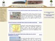
Ancient Maps of Jerusalem
This site is a joint project of the Jewish National and University Library and the Department of Geography, the Hebrew University of Jerusalem. It was made possible by generous grants of David and Fella Shapell (The JNUL digitization project) and the Hebrew University's Historic Cities Research Project.
The site contains maps of Jerusalem, and basic information concerning the map-makers and the history of cartography in Jerusalem. In the very near future we will index many of the maps and upload aerial photographs and modern maps and paintings of the city.


Jerusalem Sound Map
A map of the religious sounds from Central Jerusalem, including mosques and calls to prayer, churches and their bells, a siren at the entry of the Jewish Sabbath (Shabbat), etc.
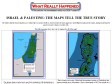
THE MAPS TELL THE TRUE STORY
The truth is that far from being the poor victim it likes to portray itself as, Israel is in fact the most aggressive and belligerent nation in the region, having invaded pretty much everyone it shares a border with.
The following maps show just who is wiping who off of the map!

Jerusalem, maps, East Jerusalem, settlements, Greater Jerusalem, Palestinian,
Maps of Jerusalem produced by Ir Amim

December 2011
Monitoring Israeli Colonization Activities
Monitoring Israeli Colonizing activities in the Palestinian West Bank and Gaza is a joint project between the Applied Research Institute in Jerusalem (ARIJ) and the Land Research Center (LRC). The project, funded by the European Union, aims at inspecting and scrutinizing Israeli colonizing activities in their different forms in the Palestinian West Bank and Gaza, and to disseminate the related information to policy makers in the European countries and to the general public. Specifically, the project will be providing accurate updates on the expansion of existing Israeli colonies, associated by-pass roads and land confiscation. It will also provide detailed baseline data related to specific sites where new Israeli colonizing activities are planned or initiated. Methods used to collect data and monitor the colonizing activities will include remote sensing satellite images, field work, aerial photographs, colonies' masterplans, and topographic maps.

POICA-Gilo Expansion and more yet to come <br> Encouraged by weak International posture toward the Peace process
Really, it was no surprise when the Israeli planning committee approved Plan 13261, Mordot Gilo at Gilo settlement southwest side of Bethlehem area. The targeted land designated for the new 1100 housing unit construction belongs to Palestinian residents from Beit Jala and was illegally annexed by Israel to the unilaterally declared Jerusalem boundary after the 1967 occupation. The approved plan 13261 comes as part of a more comprehensive construction package that includes Plan 13157 Mordot Gilo West - at Gilo settlement northwest side, which includes an additional 900 housing units and was approved earlier in July of this year. The extent of expansion designated for Gilo settlement remains ambiguous as it may involve some 1000 units more.
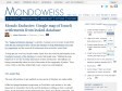
Mondo Exclusive: Google map of Israeli settlements from leaked database | Mondoweiss
The "Spiegel settlement database" is already creating waves in Israel. Israeli NGO Yesh Din has announced they will use the database to help Palestinians sue Israel for reparations and the removal of settlements from privately owned land.
1
(13 marks)