October 2013
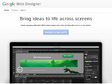
Google Web Designer
Create engaging, interactive HTML5-based designs and motion graphics that can run on any device.
June 2013

Terms and Conditions May Apply - Movie Trailers - iTunes
Admit it: you don’t really read the endless terms and conditions connected to every website you visit, phone call you make or app you download. But every day, billion-dollar corporations are learning more about your interests, your friends and family, your finances, and your secrets, and they’re not only selling the information to the highest bidder, but also sharing it with the government. And you agreed to all of it. This disquieting exposé demonstrates how every one of us is incrementally opting-in to a real-time surveillance state, click by click- and what, if anything, you can do about it.
Google Webfonts that Don’t Suck | SachaGreif.com
Webfonts services like Typekit are great, but for a lot of cases they’re just not practical.
For example, if you’re developing a WordPress theme, you can’t ask potential buyers to buy a monthly subscription, and you can’t bundle a font with the theme either unless it’s free.
Google Earth Borders as Google Maps Polygons | Devin R. Olsen Web Developer
Today we are going to cover how to extract the polygonal data from Google Earth’s country borders and encode the data into a JavaScript array that we can use in Google maps. With the combination of both polygon borders and Google style wizard you can get some stunning map results.

When Your Data Is Currency, What Does Your Privacy Cost? : Monkey See : NPR
(via)There was considerable mouth-dropping from publications such as The New York Times at initial reports this week that NSA programs are gathering both telephone records and information gleaned from large tech companies like Google and Microsoft. But as those reports have settled in, reactions have gotten more complex.
javascript - How to draw straight lines inside google map polygon - Stack Overflow
I have created a google map using google map javascript API V3. I am drawing number of zipcode polygons. The polygons are of different colors depending upon some condition. Now I want to draw straight lines/ hash marks inside some of the polygons depending upon certain criteria. How can we do it. Below is the code which I have written for drawing the polygons.


Tool for Google Maps v3 (version 3)
This application is also available with Large map.
This is a drawing tool for polyline, polygon, polygon with holes, rectangle, circle, marker(icon), direction(route, path). This application uses the Google Maps API Version 3 (V3). It has all the features of Google Maps MyMaps and has direct access to the code for the shapes (overlays) you create. It should be a full-fledged alternative. You draw and create a map with the shapes you want. KML or Javascript code is presented in the textarea. You copy KML code and paste it into a text editor. Then you have a KML file you may upload to your website. This application should now also serve as a mature alternative to my online V2 tool Digitizer tool

« J’ai 60 ans et je suis enceinte » : la vie à travers les yeux de Google | Une Zapnet Rue89
by 1 otherL’autocomplétion nous propose automatiquement un prolongement de ce qu’on tape dans un moteur de recherche, en fonction de la popularité des requêtes.
« A partir de milliards de recherches, Google a établi le profil type de ses utilisateurs et se fait le reflet des peurs, des préoccupations et des obsessions de l’être humain », explique à Webpronews.com Marius Budin, réalisateur de la vidéo « La Vie à travers les yeux de Google ».
April 2013

Google Street View Hyperlapse
by 2 othersA Teehan+Lax Labs experiment for creating interactive Google Street View hyper-lapse animations. Learn more about this project.
March 2013

ギャラリー – ストリートビュー – Google マップ
Collections de street views au Japon


How Search Works - The Story – Inside Search – Google
by 2 othersSearch. It happens billions of times a day in the blink of an eye. Explore the art and science that makes it possible.
February 2013


Redesigning Google: how Larry Page engineered a beautiful revolution | The Verge
Great design is not something anybody has traditionally expected from Google. Infamously, the company used to focus on A/B testing tiny, incremental changes like 41 different shades of blue for links instead of trusting its designers to create and execute on an overall vision. The “design philosophy that lives or dies strictly by the sword of data” led its very first visual designer, Douglas Bowman, to leave in 2009.

Exploring the Grand Canyon on Google Maps | Official Google Blog
Whether you’re planning an upcoming hike, or want to learn more about the Earth’s geological history, Google Maps can help. Today, we’re releasing panoramic imagery of one of the world’s most spectacular national monuments: the Grand Canyon. These beautiful, interactive images cover more than 75 miles of trails and surrounding roads, making our map of this area even more comprehensive, accurate and easy to use than ever before.
January 2013

See the big picture of how suburban developments are changing the country's landscape, with aerial photos and an architect's commentary
Even before Google allowed anybody with an Internet connection to see a satellite view of anyplace on the globe, I loved looking at books with aerial photography. A few favorites that focus on natural and human-made landscapes of the United States are Alex S. MacLean's Designs on the Land: Exploring American from the Air, Dolores Hayden's and photographer Jim Wark's A Field Guide to Sprawl and Alan Berger's Drosscape: Wasting Land in Urban America.

Google takes Street View off-road with backpack rig | Internet & Media - CNET News
At its "Next Dimension" Google Maps event, the company shows off a backpack rig for mapping places inaccessible to vehicles. Also: 1 billion users access Google Earth each month.

'DIY streetview' camera lets you be Google | Crave - CNET
As Google takes Street View off-road with its new Trekker backpacks, German company Streetview Technology is taking the mapping technology in yet another new direction -- DIY terrain.
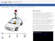
Cars, Trikes, and More – Street View – Google Maps
(via)When we first started Street View as an experimental project, we packed several computers into the back of an SUV, stuck cameras, lasers, and a GPS device on top, and drove around collecting our first imagery. Since Street View launched for five U.S. cities in May 2007, we've expanded our 360-degree panoramic views to include locations on all seven continents.
We then moved to a van for a brief period, before switching to a fleet of cars that would allow us to scale the project throughout the US and around the world. We went from a rack of computers to one small computer per car, and then set to work refining our camera system to capture higher-resolution panoramic views.
After several iterations of the car and camera technology, the latest car has 15 lenses taking 360 degrees of photos. It also has motion sensors to track its position, a hard drive to store data, a small computer running the system, and lasers to capture 3D data to determine distances within the Street View imagery.

Breadpig Shop - Buy Geeky Things & Make the World Suck Less! — Balloon Mapping Kit
Once assembled, this kit -- developed by community researchers from the Public Laboratory for Open Technology and Science -- enables you to collect your own aerial photos from up to 1000 ft. Using the open source MapKnitter web-based software, you can stitch the resulting images into a web-viewable map -- your own "counter-cartography" Google Maps. Use it to tell a different story from the "official" map -- document contamination (it was used to map the BP oil spill) or wetlands loss, or to record a temporary condition like the Occupy Oakland encampment.
October 2012

Street View and Beyond: Google’s Influence on Photography - LightBox
When Google Street View started as an experiment in 2007, the company sent SUVs equipped with cameras, GPS and lasers to collect its first pictures. The idea of capturing images of the entire world from the perspective of the street was revolutionary, if not a little insane. Now, five years later, Google has recorded 360-degree photographs of streets in more than 3,000 cities in 43 countries around the world. Google Street View cars—along with snowmobiles and giant tricycles–have covered more than five million unique miles of road since the project began, making tens of millions of still images in even the most far off places on the map, such as Antarctica.