2009
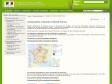
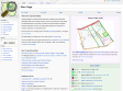
Cartographie interactive Géoïdd France
(via)"Géoïdd (Géographie et indicateurs liés au développement durable) est l'outil de cartographie interactive du Service de l’Observation et des Statistiques (SOeS). Il permet de cartographier de nombreuses informations liées au développement durable sur la métropole et les quatre départements d’outre mer. "
Calcul d'itinéraire (jogging, footing, course à pied, vélo...)
by 1 other"... permet de calculer la distance totale, ainsi que le dénivelé, d'un parcours sportif effectué (jogging, footing, course à pied, vélo, roller...) en plaçant des points sur la carte."
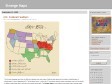
Web Maps Lite
(via)"CloudMade's Web Maps Lite API lets you embed our maps in your website." See also : Simple Map.
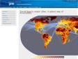
Travel time to major cities: A global map of Accessibility - European Commission
(via)"Only 10% of the land area is remote – more than 48 hours from a large city." Décidément cette planète va vraiment commencer à devenir trop petite...
2008
mapof.it
by 3 others (via)Exemple d'application utilisant Tiny Geo-coder : "... a really simple way to get a map or a route without first visiting Google Maps... ". Pratique et rapide pour aller de Paris jusqu'à Nice.
Tiny Geo-coder
by 6 others (via)Un moyen en effet très rapide de retrouver la latitude et la longitude d'une localisation dans une application.

Functional Geography 2.0: France, the Ideal Household Utensil
"An handy household item".
Geotag Icon Project
by 3 others (via)"The Geotag Icon is intended as a web "standard" icon for identifying geotagged content to humans."
2007

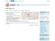
Lancement officiel de Geoportail 3D
"... les cartes géographiques disponibles sur le Géoportail prennent du volume en adoptant la 3D."
Online Maps : 50 Tools and Resources
by 1 other (via)« ... a list of the most interesting online mapping tools that some are referring to as “Maps 2.0″. »
Return Latitude and Longitude Fast with Google Maps
by 1 other« Whenever you require a location coordinates on a google map click the bookmark and a prompt box displays the in latitude and longitude. »
3-D econ map
(via)Une visualisation 3D assez étonnante (notamment pour l'Europe ?!) de l'activité économique autour de la planète.
OpenStreetMap
by 2 others« OpenStreetMap is a project aimed squarely at creating and providing free geographic data such as street maps to anyone who wants them. »
2006
KML on Google Maps
(via)« To view a KML or KMZ file on Maps, just go to Google Maps, and instead of searching for a geographical address like 1600 Amphitheatre Parkway, 94043, search for a complete Web address (including the "http://" part) of your KMZ file, like http://kml.lover.googlepages.com/cropcircles.kmz. »
Life of a Geolocated Blog Post
by 1 other (via)« View entire photo sets as self-contained KMZ files in Google Maps »
1
(22 marks)