public marks

PUBLIC MARKS from nhoizey with tags geo & image

02 March 2007 09:00

scriptaMac.at - Software
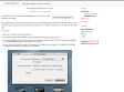
(via)
The GeoTagging Automator Action automatically tags your images with geographical coordinates and elevation data from a GPS track file. It supports a great range of image formats, including many raw image formats like Canon CR2, Nikon NEF and Adobe DNG.

nhoizey's TAGS related to tag geo

action +   api +   automator +   canon +   carte +   earth +   flickr +   flux +   free +   georss +   geotagging +   geoURI +   géo +   géolocalisation +   google +   gps +   ietf +   image +   images +   kml +   location +   logiciel +   mac +   map +   mapping +   maps +   opensource +   photo +   photography +   photos +   rss +   scheme +   tag +   tags +   uri +   url +